
The 7-day hike along the Machame route starts at the Machame gate, and has camps in Machame, Shira 2 (at the Shira cave), Barranco, Karanga, Barafu, and Mweka. The 6-day option skips the Karanga camp (only lunch is had there). Barafu is the base camp — the steep overnight walk up to the Uhuru peak starts from there.
Machame is currently the most popular route, having taken over Marangu (which has the bad reputation of being too touristic and less scenic, and called "Coca-Cola route"). Machame also offers more interesting acclimatization — the several day hike from Shira to Barafu has little elevation gain and better views (e.g. to Mt. Meru).
Climbing Kilimanjaro is only possible together with a certified guide and a group of porters (at least for a regular tourist). The guide walks before the tourist, setting the appropriate tempo (= slowly, or polepole in Swahili). The porters carry the camp, kitchen equipment, food, tourists' bags; then set up the camp (dining tent, kitchen tent, guide's tent, tourists' tent, tourists' toilet tent), pump tourists' air mattresses, prepare hot water for the tourist to soak his/her feet in it; then prepare dinner. In the morning bring morning coffee right to the tourists tent, prepare breakfast and lunch boxes (sometimes hot lunch is served instead); then clean up, pack the camp and carry it to the next campsite. The porters start out an hour later than the tourist but always pass him/her on the way, exchanging a mambo-poa or advise to go polepole, their polepole, however, is about 2 times faster than yours, although they carry a load at least 3 times heavier than yours.
The tourist carries his/her 5kg daypack (with water, rain gear, and camera) in a light daily hike (only the summit day is tougher), on arrival to camp, soaks his/her feet in hot water, then eats dinner (the food is diverse and tasty), discussing the day with the guide, and then sleeps after taking his/her Diamox pills. The success rate of reaching the peak is some 90% (this is what most climbing companies claim, Rough Guides claims "less than 1/3"), what can happen though is altitude sickness (but this is why the Diamox is there).
What should one take along to a trip to 5895m?
One would expect that the icecap of Kilimanjaro dominates the whole way from Nairobi to Arusha, or at least from Arusha to Machame. This is not the case — the sky is so hazy that the presence of a 6000-meter mountain is not detectable at all.

Tingatinga painting with animals, Mt. Meru, and Mt. Kilimanjaro. Views like shown on the painting are unfortunately not available in reality.
Apart from us there are approx. 8 other groups. (6 groups have logged their presence in the same logbook as us, but there was another logbook, e.g. our one didn't log the large 16-person American group. We were the last to leave the gate, it seemed.) Most people are between 18 and early thirties. The French group has two 50-year olds and one 60-year-old. The large American group is very mixed in many features men/women, young/old, etc.
Started at 12 o'clock from Machame gate. Met the porters at the gate. All the bags had to be weighted by the park officials. Porters cannot carry more than 25kg each. Msuri had to hire an extra porter at the gate because we had too much stuff. Started out very slowly. After a 1h hike saw 3 black-and-white colobus monkeys. Saw a few flowers (Elephantface is the local name; endogenous to Kilimanjaro). Had lunch half-way (lunch bags from an Arusha takeaway). Close to camp vegetation changed to moorland — many heather (Erica) trees: 2-3m tall with yellow flowers.

Machame camp. From left to right: kitchen tent (behind the tree), guide's tent (in the foreground), dining tent (the largest), tourists' tent (yellow).
Reached the Machame camp at 16.40 (?). The "official" estimation is 4.5h for this hike. Msuri initially calculated 6-8h, probably didn't know our speed.
Dinner: cucumber soup + fish + potatoes.
Erica forest. Kaarel's porter fell sick and returned to Arusha and checked into a hospital.
Chicken in a lunch box.
Dinner: rice + steak + peanut sauce + zucchini soup.

Shira camp. Over the clouds. From left to right: tourists' tent, toilet tent, kitchen tent, dining tent, guide's tent. The little orange dots are the porters.
A bit cold during the night, should have dressed up better for the night. Morning frosty. Left a water bottle outside, the water in it is now partly frozen.
First a gradual climb up to Lava Tower, then downhill midst the Great lobelia and Senecio. The porters take a short-cut, skipping the Lava Tower detour. Birds: Alpine chat, white-naped raven. Animals: striped mouse.
Some people from other groups have fallen sick — some have been vomiting, some walk very slowly, but nobody seems to have canceled.
Lava Tower is a big lava rock. Climbing is illegal but we see at least 5 people in the top. 4650m is now our new record (beating the peak of Mt. Kinapalu, 4095m). We get to beat the new record only on the summit day, in 3 days, as till then we just walk up-and-down, not going any higher.

Barranco camp. Similar to Shira: clouds, Mt. Meru, same landscape.
Evening very windy, blowing dust into the tents. The tents have to be fastened to the ground with rocks. I have gotten a running nose from the cold night and the dust. This will bother me till the end of the trip. Also the lips are broken from the wind.
Dinner: pumpkin soup + macaroni + mushroom + sweetcorn salad.
At night the lights of Moshi town visible. The sky is very clear with lots of stars.
First going up to 4200m. Climbing involves hands. The walking sticks which are otherwise useful, now turn out to be a burden. Amazing how the porters climb this wall: baggage on their heads, hands in the pockets.
Then going down, along an icy river. Slippery, hard without using both hands.
Finally up to the Karanga hut. The porters are already there, they did the hike in 1.5h. The people who do the 6-day Machame have only lunch at Karanga, and then continue to the Barafu camp.

Karanga camp. Mt Meru and "little Meru" over the clouds. This has been the daily view since the Shira camp.
Before dinner we walk higher for an hour, up to the point where the Barafu camp (i.e. one of its toilets) is visible.
Short walk: first up for 1h (practiced this already yesterday), then down a bit, then up to Barafu, arriving there not much later than the porters. They have started to set up the camp a bit lower from the hut. Msuri seems upset about this, shouting at the porters. They then relocated the camp to just next to the hut.
When reaching the camp, I get a headache which can be suppressed a bit by taking Ibuprofen but which doesn't really go away until the Mweka camp.

Barafu camp. The photo is taken when descending from the summit, about 30 minutes from the camp. Our dining tent (large orange) is right next to the ranger's "uniport".
Soon we get hot lunch. Then try to sleep. Then get dinner. Then try to sleep again. At 23.00 comes Oscar to wake us up. We are already fully dressed — 4 layers on the bottom (short underwear, long underwear, hiking pants, snowboarding pants), 5 layers on the top (long shirt, T-shirt, thin fleece, a bit thicker fleece, Goretex jacket), two pairs of socks, foot warmers, snowboarding gloves, scarf, wool hat.
We get a hot drink and start walking toward the peak at 23.30. We seem to be the first group to leave Barafu. Not sure why Msuri wants to leave so early. So far we have always left the camp as the last group, and reached the next camp as the first group.
Msuri goes first, then us, and finally Emmanuel (the summit porter). We originally carry 4 approx. 1l bottles each, but Msuri decides that it's too much and gives two bottles to Emmanuel.
The hike is very boring. In the darkness (i.e. only the light from the headtorch), zigzag up for 6 hours. We were the first team, so there was nobody that we could have taken over, and nobody managed to take us over either. We made about 6 stops, to rest, eat some snacks, and drink water (until it got frozen close to the top). Not sure how I entertained myself otherwise.
See also: some waypoints near the top.
Around 4.30 we reached the Stella Point. Nothing interesting there, just the track got much flatter. This is the point where the Marangu/Horombo route meets the Machame route, but nobody has arrived from there either.

GPS screenshot of the waypoint "Uhuru" that was stored when reaching the top. The "From Map Pointer" field shows the distance of the Uhuru peak from Tallinn.
At 5.30 we reach the Uhuru peak, the highest point in Africa. We take a few pictures, and start going back because it is cold and we feel very sleepy. It's still dark (still 1 hour till the sunrise), although slowly the light from behind the horizon comes in and lights the massive glacier on the right and the crater on the left.
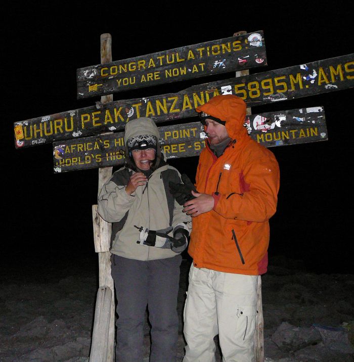
Uhuru peak, at 5.30 in the morning. The Sun rises only in 1h, but we are too cold and sleepy to wait for it, and start walking back to Barafu. There is already some light tough exposing the massive glacier on the right when walking down.
Coming down to Barafu takes about 2 hours, not anymore in the zigzag fashion, we more-or-less slide down on the loose scree. Very dusty. We catch the sunrise over Mawenzi. Gradually it starts to get warmer. Head is aching hard.
Back at Barafu we are congratulated by the porters and get a glass of mango (?) juice for breakfast. Then go to tent to sleep, but it's already quite hot, so it's unpleasant to sleep.
Sleep for approx. 3 hours. Then start out to Mweka. Pass through High Camp, where the alpine desert changes into a [BUG: what?]. The humidity gets quite high.

Distributed the tips after breakfast and took a group photo. Then the guys sang the Kilimanjaro Song and danced a bit. Then we walked down to the Mweka gate. The humidity was very high, and for a while it was even raining. Didn't spot any animals, although the black-and-white colobus monkeys are supposed to be more frequent here than along the 1st day's route.
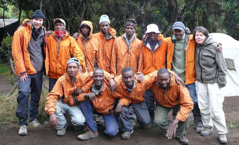
Duma Explorers (see also http://www.dumaexplorer.com) at the Mweka camp in the morning of the last day on Kilimanjaro.
Front row: Oscar, Anderson, Tadei, Dickson.
Back row: Kaarel, Benson, Jackson?, Emmanuel, Godson?, Godwin, Msuri, Csilla.
(Missing Rajabu.)
The porters passed us again during the hike, although it was really short (3 hours?). Once we arrived at the gate they had already changed their clothes, and some had left.
Msuri retrieved the certificates, and we bought a drink (beer, fanta, coke; 24 USD in total) for the guys who had not left yet. While we were having the drinks, the locals managed to sell us a Kilimanjaro badge (? TSh), Kilimanjaro T-shirt (10 USD), and a banana-leaf-picture of a Chagga hut (8000 TSh). Then drove back to Arusha with Msuri, Anderson, and Godwin (they all live in Arusha). First through coffee plantations, then through Moshi town.
7-day hike along the Machame route from Machame gate to Mweka gate incl. a brief stop at the highest point in Africa (Uhuru peak). Note that there is a full recording only for the last 3 days. (See also everytrail.com, and look for logs provided by teofilus, a Polish guy who did a 6-day Machame hike starting on the same day as we.)
...